Hello, King’s Chair at Oak Mountain State Park in Pelham near Birmingham, Alabama

After arriving back to Atlanta upon the conclusion of my one-week trip to the West Coast, I picked up my truck, spent one more night in Atlanta to rest up, then drove to Birmingham, Alabama to continue on my road trip. For my first adventure in Birmingham, I drove to the adjacent neighborhood of Pelham to visit the Oak Mountain State Park.

I didn’t really do the best job in planning interesting activities along this path—I mainly scheduled things out with a plan to get back to Las Vegas via vehicle by early December so I can wrap up some classes for one of my continuing education certifications—so I based the remainder of my road trip on that, rather than looking at what interesting things are along the way. That ended up being unfortunate for Birmingham, because if I had known there was such a nice state park, I would’ve spent more days here.

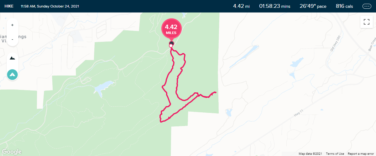
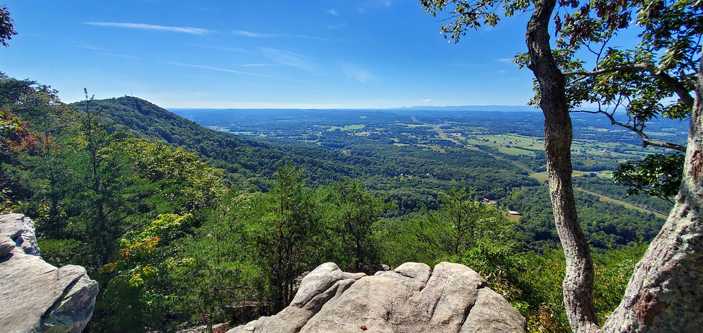
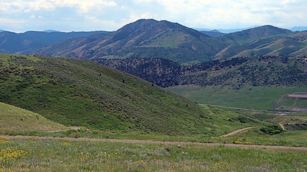
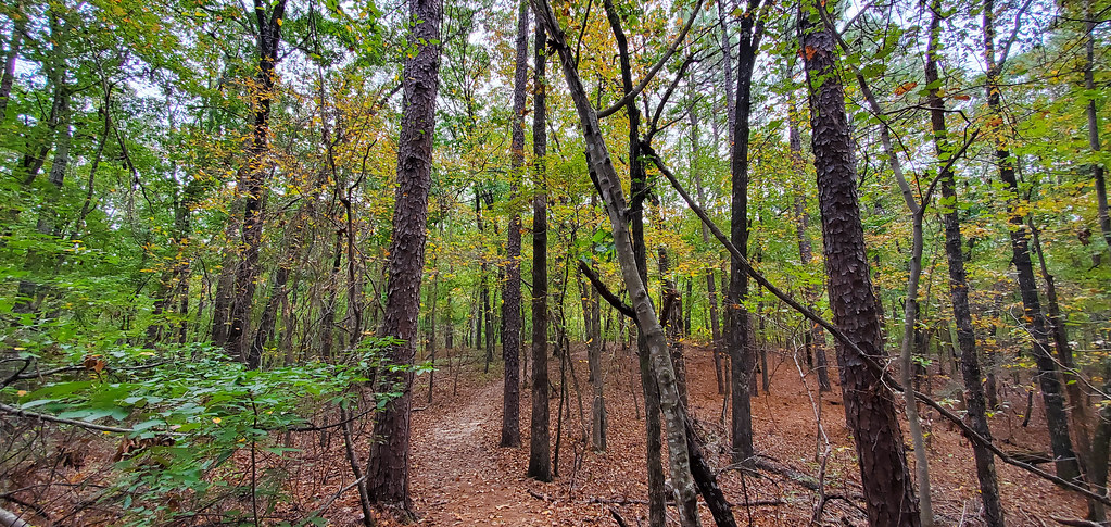
I wanted to hike an intermediate trail and selected King’s Chair on the eastern side of the state park. The trip to the summit was fairly stereotypical for a moderate hike like this, with nice elevation gain, scattered simple obstacles, and plenty of fresh air.

Oak Mountain State Park

Once you get to the top of the mountain, there is a relatively flatter portion along the ridge with a few pseudo-summits before hitting King’s Chair. The first, which I found out from another hiker, is called Queen’s Chair.

Oak Mountain State Park

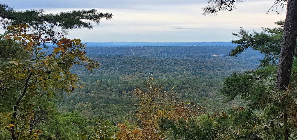
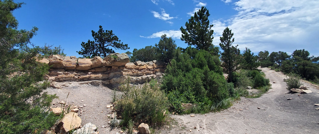
A little farther down was another opening, which I originally thought was King’s Chair, but later discovered that it wasn’t. There was a little platform where you could sit down, so maybe we can call it King’s Bench.

Oak Mountain State Park

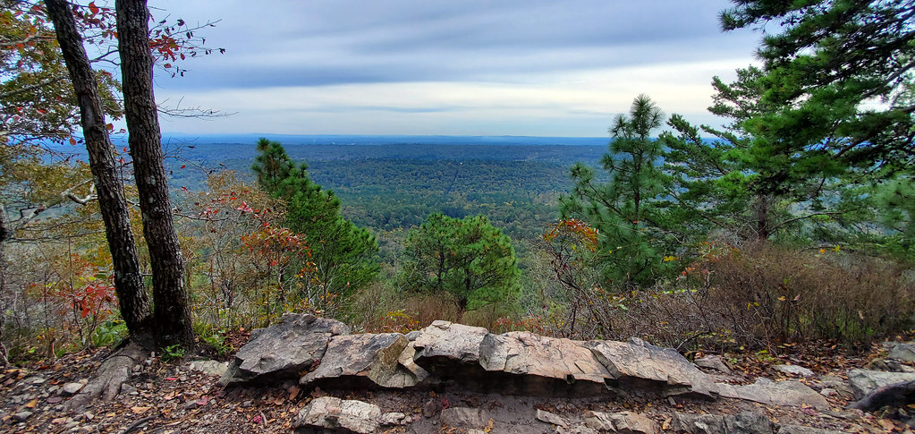
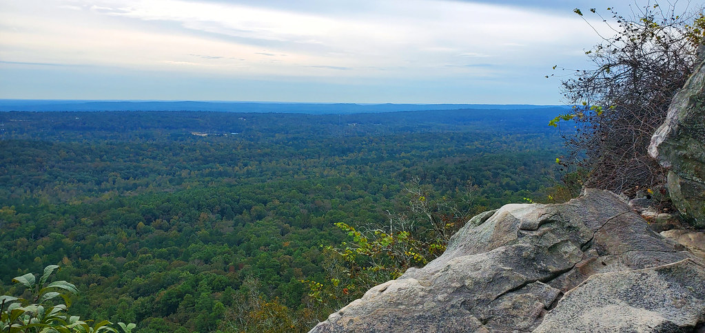
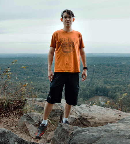
And finally, all the way at the end of the trail was King’s Chair.

Oak Mountain State Park

Oak Mountain State Park

I’ve touched on this a few times in the past, but people out in the “middle of nowhere” areas (and yes, I know that Birmingham technically isn’t the middle of nowhere, but I’ve historically seen everything outside of Chicago, Los Angeles, New York City, and, to some extent, Las Vegas, as the “middle of nowhere”) are much kinder and more caring. The culture in big cities is to ignore everyone around you and just do your own thing, but as I started vi­sit­ing smaller cities and exploring out into the country, I’ve had much more pleasant interactions.

Oak Mountain State ParkI’m not really that social of a person in general, but after I realized that it is nor­mal to interact with each other in these areas, and that I might actually be mak­ing people feel uncomfortable by having a “city attitude,” I’ve been much more receptive of social interaction and light conversation with random people I meet in public.

I’ve learned a lot about the world by taking this more open approach to others, and I think I’ve also taught a lot to others by sharing my own stories of what busy city life is like. A lot of my most interesting encounters have been the most unexpected, and I think my interaction here at the summit of King’s Chair tops the charts in unexpectedness.

I met a guy named Hunter who was hiking with his friend. Apparently Hunter used to be an aspiring professional gamer, and he was familiar with Tempo Storm and our past esports endeavors. He’s doing photography now, and offered to take a picture of me, which I obviously accepted.

The top of a mountain in the middle of Alabama is probably one of the last places I would’ve anticipated meeting an esports fan, but I’m glad that we talked for long enough to figure that out, because this experience definitely made my visit to the state much more memorable.

After parting ways with my new friends, I walked across the ridge in the opposite direction, then took a different path down to the trailhead.

Oak Mountain State Park

Apart from the novelty of my conversation at the summit, the rest of the hike was fairly routine. Oak Mountain State Park is a decently large recreation area, and if I was staying in Birmingham for longer, I definitely would’ve come back at least a couple more times to hike a few more trails.

Oak Mountain State Park


—§—


Hello, Latta Nature Preserve in Huntersville near Charlotte, North Carolina

Continuing my trend of outdoor activities, I decided to explore the Latta Nature Preserve after arriving in Huntersville, just north of Charlotte, North Carolina. The Latta Nature Preserve is a large nature preserve that supposedly has 1,460 acres of land and 16 miles of trails. I obviously couldn’t explore it all in one day, so I took two hiking trips spread across two separate days to see as much of it as I could.

Latta Nature Preserve in Huntersville, NC

I started by going to the waterfront near the Historic Latta Plantation and hiked the Buzzard Rock Trail. At the end was Buzzard Rock and a little plat­form that had a nice view of Mountain Island Lake.

Latta Nature Preserve in Huntersville, NC

Latta Nature Preserve in Huntersville, NC

After retracing my steps for a bit, I continued onto Laura’s Trail which led me to Wash Rock, another lookout spot that had a view of Mountain Island Lake from a different angle.

Latta Nature Preserve in Huntersville, NC

Latta Nature Preserve in Huntersville, NC

From there, I got a little lost and started taking any trail I could find, which ended up being the Shady Trail up to the Carolina Raptor Center, then back via Catawba Trail. After returning to my parking spot at the waterfront, I continued going south to check out the beachy area.

Latta Nature Preserve in Huntersville, NC

Latta Nature Preserve in Huntersville, NC

On the second day, I started at the Latta Plantation Nature Center and headed north on Hill Trail before connecting onto Cove Trail and returning via Split Rock Trail. This particular route didn’t have as many spots with nice views, but I did catch some of the Catawba River from the Cove Trail at the tip of one of the peninsulas.

Latta Nature Preserve in Huntersville, NC

Latta Nature Preserve in Huntersville, NC

In total, my adventure spanned across just over eight and a half miles and took right around three hours to complete.

Latta Nature Preserve in Huntersville, NC

By the way things are looking now, it seems like I might not have time to go on any other tourist activities, but at the very least, I’m hoping I can squeeze in another hike on a different trail before I head to my next city.


—§—


Hello, House Mountain and Calloway Ridge in Greater Knoxville

Ever since arriving in Knoxville, I’ve mostly been taking it easy, catching up on work, exercising at the hotel gym, and otherwise just relaxing.

While in the city, I wanted to go see the Sunsphere Tower, but apparently that is closed right now. Knoxville also has a zoo, but I’ve already been to a bunch of zoos in the past year or so and wasn’t really in the mood; there’s also an art museum, but I just went to a really big art museum in Indianapolis and also wasn’t too interested in that at the moment either.

Instead, I decided to go on some nature adventures. I haven’t had a chance to go hiking lately ever since leaving the West, considering how flat the Mid­west is, but the terrain here is much more dynamic as I approach the Appalachian Mountains. I looked up some trails of moderate difficulty and se­lect­ed House Mountain as my first trip.

House Mountain

There are two initial impressions that I had upon arriving. The first is that it was a lot rockier than I thought it would be—there were a lot of large boul­ders laying around, and the path was littered with smaller rocks. The second is that I really appreciated how foresty it was and how many trees were tightly wrapping the trail—this blocked out a lot of the sun and made the hike much more comfortable.

House Mountain had a strange layout. Usually when you’re hiking a mountain, the summit is all the way at the edge of the path, and is the highest point in elevation. For House Mountain, the main summit appeared to be towards the middle of the trail, where I was able to get a nice, sweeping view of the north.

House Mountain

House Mountain

There was also a secondary summit, also somewhat in the middle of the trail. This one was actually a bit difficult to find, because this one involved walk­ing away from the main path a bit and going on a side path that wasn’t obvious on the satellite imagery from Google Maps.

House Mountain

Apart from that, the far edges of the trail weren’t really that interesting—there were so many trees that it was impossible to get a nice view from the northeastern-most or western lookout points.

According to information I found online, it appears like I hiked a total of about four miles, with an overall elevation gain of 1,017 feet.

 
A few days later, I went on a significantly easier trail, the Concord Quarry Trail on Calloway Ridge. This one had a less clear-cut path and was instead a bunch of winding loops that interconnected.

Calloway Ridge

I started off by going on the southern loop that had a nice view of of the Fort Loudoun Lake, which I wasn’t able to see from elsewhere on the trail due to the dense forest.

Calloway Ridge

On the loop back in, I also came across this small lake near the entrance of the west trails.

Calloway Ridge

Apart from that, the rest of the trail was fairly straightforward. The length of all the trails (if you go on all the paths and do all the loops) was right around 3 miles, with a total elevation gain of 262 feet.

Calloway Ridge

During my hike, I saw a sign that said “Rocky Point” was approaching. I thought this would be a high point where I’d be able to take in a nice view, but was disappointed when I realized it just pointed to a dead end.

I later found out that the sign was technically right, but wasn’t very useful—it was pointing towards the general direction of Rocky Point Park, but there was no feasible way to get from the sign to Rocky Point without going through dense forest and crossing a street. If I had known this beforehand, I would’ve made a stop at the park to see the northeastern sound of Fort Loudoun Lake.

 
And with that, I wrap up my week in Knoxville. This was probably the least eventful city I’ve visited, but it wasn’t bad, and I also appreciated how vi­su­al­ly nice Tennessee is.

My next destination will be Charlotte, North Carolina. When I first drove through the Virgin River Gorge and other mountain ranges in the West for the first time, I was impressed by the scenery. I will be cutting through the Appalachian Mountains on my way to North Carolina, so I’m very much looking forward to being hugged by tall mountains again during my drive, but this time by mountains that will be much greener.


—§—


Hello, Dinosaur Ridge in Jefferson County of the Denver Metropolitan Area, Colorado

Yes, I know that the title of this blog post, as well as the one about Green Mountain, are a little ridiculous… but if you know me, you know that I like doing things right, and neither of these landmarks are officially within Denver (and Dinosaur Ridge isn’t even officially in any city), so they’re a little dif­fi­cult to describe.

Dinosaur Ridge in Colorado

Anyway, for my final touristic activity of this leg of my trip, I headed over to the Dakota Ridge Trail to hike up Dinosaur Ridge. Dinosaur Ridge is right by Green Mountain, which I visited a few days ago, but I decided on this trail instead of something deeper west into the mountains because it already takes over half an hour for me to drive to this area from where I’m staying in Centennial. Because of this, you might recognize some of the scenery from these photos if you already read my Green Mountain blog post, but just from a closer or further point-of-view.

Dinosaur Ridge in Colorado

This hike was longer, but it was definitely easier than going up Green Mountain, and I only ended up climbing about half the elevation that I did for Green Mountain. The intensity of the climb wasn’t much different than Green Mountain, though; a lot of the elevation gain happens right at the be­gin­ning of the hike, then it plateaus out once you reach the top of the ridge.

Dinosaur Ridge in Colorado

Dinosaur Ridge in Colorado

At the summit, there was a little flat platform of land where you could see Denver, and also transfer over to Zorro Trail if you wanted.

Dinosaur Ridge in Colorado

Dinosaur Ridge in Colorado

Instead of transferring, I instead chose to continue along the upper ridge of Dinosaur Ridge. I checked a handful of maps and wasn’t able to find a spe­cif­ic name for this trail, but it ran parallel to Dakota Ridge Trail. This path was much more woody and foresty.

Dinosaur Ridge in Colorado

Once I got to the tip, I was able to get sweeping views to the north, with a sharp cliff down.

Dinosaur Ridge in Colorado

Dinosaur Ridge in Colorado

And with that, that wraps up my trip to Denver. I’m glad my final activity was a hiking trip, because I’m headed eastbound to Kansas tomorrow, and I’m definitely not going to be seeing any more mountains for a long time. My visits to Utah, Wyoming, and Denver were fantastic, and I’m hoping that I won’t be let down by the rest of my journey through the Midwest.


—§—


Hello, Green Mountain in Lakewood of the Denver Metropolitan Area, Colorado

I made it into Denver Metropolitan Area from Rawlins, Wyoming this past Monday after a drive that lasted just shy of 4 hours.

The drive was pleasant with a decent amount of scenery, especially after entering into Colorado. With the state border receiving drizzles of scattered show­ers, the air smelled crisp and refreshing—a pleasant contrast from the polluted air of the cities in which I usually am. I also had a work call during my drive, which made that hour feel like it went by a lot faster. Overall, the trip felt fairly quick.

My hotel of choice for this leg of my trip is the Courtyard by Marriott Denver South/Park Meadows Mall, south of the main Denver city/county and near Centennial. (Interestingly, the hotel has an Englewood address, even though Englewood is several miles northwest of Centennial; I haven’t figured out why yet.)

Since arriving, I spent Monday night and most of Tuesday catching up on work and relaxing. I’m heading out of Colorado on Saturday, so I didn’t want to lose any more days; I went on my first hike this morning.

Green Mountain in Lakewood, Colorado

When selecting hikes, I like to pick trails that are moderate or intermediate in difficulty that will allow me to overlook the city with a wide, sweeping view. For today’s hike, I wanted to summit Green Mountain in Lakewood. I headed over to the Rooney Road Trailhead and made my way up the Rooney Valley Trail.

Green Mountain in Lakewood, Colorado

Green Mountain in Lakewood, Colorado

Once I got close to the summit, I transferred over to the Summit Loop Trail for a nice view of the entire Denver Metropolitan Area.

Green Mountain in Lakewood, Colorado

Green Mountain in Lakewood, Colorado

Green Mountain in Lakewood, Colorado

Green Mountain in Lakewood, Colorado

After reaching the peak of Summit Loop, I transferred back over to the Rooney Valley Trail and summited Green Mountain, which gave me some nice views of the southwest corner of the Denver Metropolitan Area.

Green Mountain in Lakewood, Colorado

Green Mountain in Lakewood, Colorado

It seems like the Denver area has a lot of great hiking opportunities. Unfortunately, I’ll only have time to hit two more spots at most, but I’ll definitely be putting my final two full days in town to good use.


—§—


Hello, Great Salt Lake in Utah

Due to my broken eyeglass incident (which, by the way, has an update now that I edited in yesterday), I feel like four out of the six and a half days I had in Salt Lake City were robbed from me—the first day when my glasses snapped in half at the bridge, the second day when I drove around to a repair shop and eyeglass store trying to figure out how to resolve the situation, the following day when I tried to get accustomed to my new glasses and failed hard, and yesterday when my glasses snapped in half at the leg.

With that being said, I think I still hit the two most important places that I wanted to visit in Salt Lake City—Ensign Peak, where I was able to get sweep­ing views of the entire metropolitan area, and Great Salt Lake, the body of water after which Salt Lake City is named.

Great Salt Lake

I went to Great Salt Lake by means of the Great Salt Lake State Park, southwest of the Great Saltair; admission was $5. The park had an observation deck with a good lookout spot of the lake and beach.

Great Salt Lake

There was also a beach access spot, so I went down to the sand… which was a questionable decision. I imagine it’s because of the high salt content in the lake, but there was an absolute insane amount of bugs on Silver Sands Beach. In the photograph below, you’ll see some gray stuff floating along the shore­line, as well as on the green sand. … Those are all bugs.

Great Salt Lake

There were some areas of cleaner sand, but the entire area smelled terrible, presumably because of the bugs. I walked close to the water and got swarmed by bugs, and they followed me a good couple hundred feet back to the park.

Great Salt Lake

There was another nice lookout point at the edge of the park that overlooked the opening for boats to sail off from the marina into the lake. The area looked like it was closed down, so not many people went over there, but it seemed like the blockade was only to stop vehicles from passing through that area. I went around the barrier and walked all the way down onto the rocks.

Great Salt Lake

On my way back, I snapped a photo of the marina.

Great Salt Lake

And behind the Great Salt Lake State Park, the Oquirrh Mountains served as a nice backdrop.

Great Salt Lake

I don’t get too grossed out by anything, so I was fine walking around Silver Sands Beach, but it was quite frankly hilarious watching some of the other tour­ists go down there and freak out at the smell and bugs.

I’ve stared into the vast nothingness of the Pacific Ocean at astronomical twilight from a high point at the Palos Verdes Peninsula in Los Angeles, so star­ing into the Great Salt Lake wasn’t anything too life-changing, but I definitely enjoyed the experience.

Today is my final full day in Utah; tomorrow, I set off for Wyoming.


—§—